

Introduction to Roosevelt Island and the East River
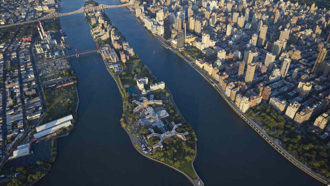
Roosevelt Island East River is one of those New York City combinations that sounds simple but tells a much bigger story. Roosevelt Island sits in the East River between Manhattan and Queens, creating a narrow urban community surrounded by water on nearly every side. Despite being so close to some of the busiest parts of New York, the island has a noticeably different atmosphere, with residential buildings, open spaces, waterfront paths, historic sites, and impressive views of the Manhattan skyline.
The location is one of the island’s biggest attractions. From the eastern side, visitors can look toward Queens, while the western waterfront provides dramatic views of Manhattan. The East River acts almost like a natural boundary, giving Roosevelt Island a sense of separation without making it feel isolated. It is still firmly part of New York City, yet walking along the waterfront can feel surprisingly calm compared with the streets of Midtown Manhattan.
The relationship between the island and the river has shaped its identity for centuries. Before becoming the residential neighborhood people know today, the island went through several different uses and names. Its location in the East River made it strategically important, while later development transformed it into a planned urban community. Today, the waterfront remains central to the experience of visiting or living on Roosevelt Island.
Where Roosevelt Island Is Located
Roosevelt Island is approximately two miles long and relatively narrow, stretching between Manhattan and Queens in the East River. Its position places it directly alongside some of Manhattan’s most recognizable landmarks. Midtown Manhattan is immediately to the west, while Long Island City is across the river to the east.
The island’s location makes it particularly interesting from a transportation perspective. Although surrounded by water, Roosevelt Island is not difficult to reach. The Roosevelt Island Tramway provides one of the most memorable approaches, carrying passengers above the East River between Manhattan and the island. The F subway service also connects Roosevelt Island with Manhattan and Queens, making the community accessible without a car.
This central position also explains why the island offers such unusual views. Looking west, visitors can see the Manhattan skyline from a perspective that is quite different from typical waterfront observation points. Depending on the location and time of day, the Empire State Building, Chrysler Building, United Nations complex, bridges, and Midtown towers can become part of the same panoramic scene.
The East River Waterfront Experience
One of the best ways to appreciate Roosevelt Island is to walk beside the East River. The waterfront paths provide a slower alternative to the crowded sidewalks found elsewhere in New York. Instead of constantly navigating through traffic and dense crowds, visitors can enjoy open views of the water while watching boats move along the river.
The eastern and western sides of the island offer different visual experiences. The western shoreline is particularly attractive for skyline photography because Manhattan rises dramatically across the water. The eastern side looks toward Queens and Long Island City, where the urban landscape has developed rapidly over the past several decades.
The river also changes character throughout the day. Morning light can create a softer atmosphere around the Manhattan skyline, while late afternoon and sunset can produce striking reflections across the water. At night, the illuminated buildings create another completely different scene. For photographers, walkers, and anyone who simply enjoys city views, the waterfront can easily become the highlight of a Roosevelt Island visit.
A Brief History of Roosevelt Island
The island has a much longer history than its modern apartment buildings might suggest. It was previously known by names including Blackwell’s Island and Welfare Island, reflecting different periods in its development. For many years, the island was associated with institutions such as hospitals, prisons, and charitable facilities.
Some of those historic structures still contribute to the island’s character. The Octagon, for example, is a well-known surviving landmark that connects present-day Roosevelt Island with its institutional past. Other remnants and historic sites can be found throughout the community, offering clues about how dramatically the island’s role has changed.
The island was renamed Roosevelt Island in 1973 in honor of President Franklin D. Roosevelt. Around the same period, major redevelopment began changing its physical and social character. Rather than remaining primarily institutional, the island was planned as a modern residential community with parks, pedestrian areas, and public facilities.
Roosevelt Island’s Parks and Open Spaces
Despite being surrounded by one of the world’s busiest rivers, Roosevelt Island contains several spaces where people can slow down and enjoy the outdoors. The island’s green areas are an important part of its identity because they provide room to walk, relax, exercise, or simply sit and look at the skyline.
Four Freedoms State Park is among the most recognizable destinations. Located at the southern end of the island, the park is dedicated to Franklin D. Roosevelt’s famous Four Freedoms speech. Its design creates a powerful relationship between architecture, open space, and the surrounding river.
The park is also an excellent place to understand why Roosevelt Island feels different from much of Manhattan. The city skyline remains visible, but the immediate environment is spacious and relatively quiet. Visitors can stand near the water and appreciate the contrast between the peaceful park and the dense architecture across the East River.
The Roosevelt Island Tramway and River Views
The Roosevelt Island Tramway is more than transportation. For many visitors, the ride itself is part of the attraction. The cabins travel above the East River, giving passengers an elevated perspective of Manhattan, Roosevelt Island, and the surrounding bridges and buildings.
The aerial journey offers views that cannot be experienced from a normal subway train or street-level walkway. As the tram moves between Manhattan and Roosevelt Island, the river becomes the dominant feature below. The surrounding city appears both close and distant at the same time, which is one reason the tramway has become such an iconic part of the island experience.
For first-time visitors, taking the tram can be a particularly enjoyable introduction to Roosevelt Island. Even if the island is the final destination, the trip provides a quick visual explanation of its unusual geography. You can immediately see how narrow the island is and how completely its identity is connected to the East River.
What Makes Roosevelt Island Different From Manhattan
Roosevelt Island technically belongs to Manhattan, but the experience of being there is noticeably different from visiting Midtown. The island is primarily residential, and its streets and pathways generally feel less hectic than nearby Manhattan neighborhoods. There are fewer commercial distractions, and the river creates a natural separation from the city’s constant movement.
That does not mean Roosevelt Island is disconnected from New York life. Residents can reach Manhattan quickly, while Queens is also nearby. The island has schools, parks, community facilities, restaurants, and residential buildings, giving it many of the characteristics of a self-contained neighborhood.
Its unusual balance between accessibility and quietness is one of its strongest qualities. Someone can spend the morning surrounded by the energy of Midtown and then cross to Roosevelt Island for a waterfront walk where the pace feels considerably slower. That contrast is difficult to find in such a central part of New York.
Best Things to See Along the Roosevelt Island East River Waterfront
A waterfront visit does not need to follow a complicated itinerary. Simply walking from one end of the island to another can reveal many of its most interesting features. The riverfront paths offer changing perspectives of Manhattan and Queens, while parks and historic landmarks provide natural stopping points.
The southern end deserves special attention because of Four Freedoms State Park and its striking views toward Manhattan. The northern end, meanwhile, offers a different atmosphere and access to historic elements of the island. Walking between these areas gives visitors a better sense of Roosevelt Island’s shape and scale.
The waterfront is also a good place to appreciate New York’s bridges and transportation infrastructure. Depending on where you stand, you may see the Queensboro Bridge, East River traffic, subway infrastructure, and the Roosevelt Island Tramway operating overhead. These details create a fascinating combination of architecture, engineering, and natural scenery.
When to Visit Roosevelt Island
Roosevelt Island can be visited throughout the year, but the experience changes significantly with the seasons. Spring brings fresh greenery and comfortable conditions for walking. Summer provides longer daylight hours and lively waterfront activity, although the midday sun can be strong.
Autumn is especially attractive for people who enjoy photography and quieter walks. Cooler temperatures make it easier to explore on foot, while seasonal changes in the island’s greenery add another layer to the scenery. Winter can be cold and windy along the river, but clear days can provide exceptionally sharp skyline views.
Time of day matters as well. Early morning is ideal for a peaceful walk, while afternoon provides strong visibility for sightseeing. Around sunset, the relationship between the river and the Manhattan skyline becomes particularly impressive. After dark, the illuminated buildings create a completely different cityscape.
Tips for Exploring Roosevelt Island
A comfortable pair of walking shoes is one of the most useful things to bring. Roosevelt Island may look small on a map, but exploring the waterfront, parks, historic sites, and different viewpoints can involve considerably more walking than expected.
It is also worth allowing more time than you might initially think. A quick trip can cover the basic highlights, but spending several hours gives you the opportunity to slow down and enjoy the river. Rather than treating the island as just a place to take a few skyline photographs, consider exploring it as a neighborhood with its own history and personality.
Visitors should also check current transportation information before traveling, particularly if they plan to use the tram. Weather can influence the waterfront experience, too. Wind conditions can feel stronger than they do several blocks inland, so dressing appropriately is especially useful during colder months.
Why Roosevelt Island East River Is Worth Exploring
Roosevelt Island East River represents a fascinating side of New York City that is easy to overlook. Its location places it directly in the middle of one of the world’s most famous urban environments, yet the island maintains a distinct sense of space and calm.
Its history adds another layer to the experience. Historic buildings and landmarks reveal a past very different from the residential community that exists today. Meanwhile, parks, waterfront paths, and modern transportation demonstrate how the island has been repeatedly reinvented.
Most importantly, Roosevelt Island offers a perspective on New York that cannot be duplicated from the traditional tourist routes. The skyline is still there, the river is still moving, and the city remains incredibly close, but the viewpoint is different. Whether you are interested in architecture, history, photography, urban planning, or simply finding a peaceful place to walk, Roosevelt Island provides a memorable way to experience the East River and the city around it.
You May Also Raed: Englishtistic